WEC’s Right-of-Way Coordinator Describes how AI Supports Plans to Trim Trees and Reduce Outages
The work of reducing outages proactively in a forested utility territory is ongoing—never finished.
In WEC’s heavily forested territory, falling trees are the most frequent cause of outages. And in member surveys, WEC members consistently say reliability is what they value the most.
But as long as there are trees, there will be outages. From the Co-op’s founding up through the 1970s, the Rural Utilities Service (RUS)—WEC’s federal lender—would not lend money to route lines along roadways. Lender requirements stipulated lines could be set only along the shortest distances, which meant across open pastures, explained longtime WEC Treasurer Don Douglas. “Lines were set through fields. Those fields are now forests,” said Douglas.
Maintaining 1,200 miles of rights-of-way has been a challenge from the beginning, especially as fields reverted to forests. Eventually RUS changed policies to lend for relocating lines to roads, but WEC still has hundreds of miles of heavily forested line. Right-of-way tree trimming has always been a focus for WEC, especially given the value members place on reliability, said Douglas. “The greatest balance the Board and staff have to come up with is, do you spend $1 million or $10 million on rights-of-way? Because you could spend either,” he said. “And no matter what, you’ll have outages, because trees fall from outside the right-of-way. No matter how much you spend on rights-of-way, there will always be outages.”
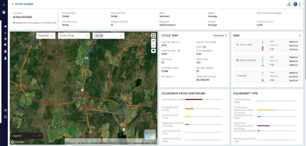
Member alerts about overgrowth have always been an important part of WEC’s tree cutting plans, as has information from line crews who work daily on the system. Now WEC may have a new tool in its belt. Recently, WEC opted to try out new software coupled with satellite data, called AiDash, to see if it improves the Co-op’s ability to manage tree trimming in its rights-of-way and reduce outages. AiDash, which describes its program for electric utilities as “satellite based vegetation management,” claims its clients see a 10% improvement in reliability, as well as reduced costs and faster storm recovery.
Meet Patrick Davis
A co-op like WEC is as informed by its history, geography, and relationships as it is by data. In March, WEC hired Right-of-Way Coordinator Patrick Davis, a seasoned forester who brings to his work both the ability to use and understand software like AiDash, plus an appreciation for the information that comes from walking along the lines and talking to members.
Davis moved to Calais from Durham, North Carolina. He and his wife both have family in the Northeast, and they’re pleased to be closer to them. Davis, originally from the Finger Lakes region of New York, earned degrees in forestry resource management from the SUNY College of Environmental Science and Forestry in Syracuse, and worked both as a consulting arborist—traveling up and down the east coast looking at trees in public spaces—and later as a planning forester for the city of Raleigh. “I’ve had jobs where I’m looking at specific trees, and where I’m looking at the whole system,” he explained.
Davis observed that trees grow differently in northern New England than in southern regions. For one thing, in heavily forested Vermont, trees grow much more readily than in more urban areas. “When we have to remove a tree, it can be sad, if it’s a notable tree. But the truth is, there’s going to be a tree growing right back in its place,” he explained. “It’s not like that in other places where there is severe canopy loss and a lot of impervious surfaces,” like concrete and paved roads. And while managing fast-growing vegetation is a challenge to maintain and creates obstacles for lineworkers, he said, “for forest health, it’s great.” This is a happy balance for a forester: Davis said his job is to limit the impacts of vegetation to utility infrastructure, to make rights-of-way safe for line crews to work, and ultimately to improve power reliability. Basically, the work of reducing outages proactively in a forested utility territory is ongoing—never finished.
The new software, Davis commented, is already improving efficiency, because it includes work-planning software. This helps him assign sections of line to subcontracted tree crews. “You can get mileage and cost estimates for tree crews. Previously, this was all done manually,” he observed.
In terms of vegetation, the software helps WEC understand its system better and prioritize decisions. It includes a mapping interface, like any digital map with a satellite view, and tables with data analysis. From a big picture perspective, the software identifies areas most in need of trimming. What the AiDash demo showed is a portrait of WEC lines that may be familiar to many members: yes, there is a lot of vegetation growth; but that overgrowth is not universal, said Davis. Instead, it’s interspersed with many well-trimmed sections of line. “The more you analyze, the more nuanced the data,” Davis said.
There are no easy fixes when it comes to managing WEC’s rights-of-way. Davis still needs to prioritize the highest risk sections and work within his right-of-way budget. Right now he’s setting up bids for cycle trimming, or trimming an entire section of line at a time. It’s more cost-efficient, he said, and as a result it’s the industry standard for right-of-way clearing. But it takes planning and labor, and in the meantime, some sections of line that aren’t in a particular year’s cycle may be so high-risk they require trimming too. This off-cycle trimming, called “hot-spotting” in industry language, is also supported through AiDash. “It will help identify areas both in need of trimming now and areas that will provide the most outage-reducing potential,” said Davis.
It’s helpful to have software that works in parallel with word-of-mouth reporting, he said: when someone reports a section of right-of-way that’s badly overgrown, “I’m always going to go look,” he pledged. And he’s already observed a lot of overlap between what’s informally reported and what’s shown through data analysis.
Davis enjoys the connection between data and observation, and requested that if members are concerned about vegetation growth in their rights-of-way, give him a call. “I’m pretty responsive to member calls and emails,” he said, “and I’m really enjoying getting to know our members.”
Reach ROW Coordinator Patrick Davis at Patrick.Davis@wec.coop or by calling the WEC office at 802-244-2339.
Below: a screenshot of AiDash software shows how satellite imagery and tech give Davis and colleagues a new way to visualize WEC’s lines.